 English
  Ελληνικα

ELIOS PRONNI
Introduction Accommodations
The Μunicipality of Elios – Pronni stretches along the south-eastern side of the very beautiful and green island of Kefalonia.
The island of contrasts and incomparable beauty wins the heart of every visitor.
The shoreline of Kefalonia varies from sheltered bays, which are ideal for swimming and fishing, to steep cliffs with jagged rocks washed by the clear blue waters of the Ionian Sea.
View photos of the area
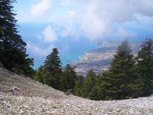 A special feature of Kefalonia is the unique variety of black fir tree, the Kefalonia Fir (Abies Kefalonica), which grows only on the highest mountain of the island, Ainos.
From the Ainos National Park, you can admire the stunning view that unfolds before your eyes between the dark green trees of the mountain. Rear predatory birds can be seen in the region, as well as the mountain’s own wild horses near the village of Arginia, that belongs to our Municipality.
There is evidence that man has lived on the island since the Palaeolithic era, from possibly as long ago as 40.000 BC.
In the ancient times, the island was devided up into four autonomous regions that constituted the “Kefalonian Tetrapolis”: Sami, Krani, Pronni and Palli.
The four cities were democracies, supporting the Greeks in the Persian wars, and afterwards forging alliances with various powerful leaders of that time and providing them with a well-trained navy.
Pronni occupies the southernmost part of the island. The historian Polivios mentions Poros as beeing the port of Pronni.
The Municipality of Elios-Pronni has a rich cultural tradition and holds many cultural events such as exhibitions, and musical or theatrical plays featuring both local and visiting performers, which are well-supported by the local community.
The Municipality has the initiative in helding these events, as well as the activeness of the residents.
Regional festivals are organised during the summer, when you can see the the local dances- Balos, Divaratikos and “Kantrilies” (quadrilles).
For those who love walking, there are plenty of picturesque spots and delightful forest paths to choose from.
Fans of water-sports can enjoy sailing and diving here.
The beaches of Aragia, Saint Barbara and Skala have all received the European “Blue Flag” award for the past few years.
The region is well-known for its excellent tourist infrastructure and modern facilities, which, together with the local hospitality, make your stay here unforgettable.
HISTORY
 Significant historical and archaeological finds from prehistoric times show that building work has been carried out throughout history in the region where the Municipality of Elios-Pronni is located today.
The recently discovered remains of a prehistoric wall near Arginia on the eastern slopes of Ainos, the excavations of palaeolithic utensils and tools in the Drakaina Cave in Poros, tools found near Skala, chamber tombs in Mavrata, and finally the royal tomb near the village of Tzannata with its artefacts made of gold- all bear witness to a united area with the fortress of “Palaiokastro”, the ancient castle of Pronni, at the centre of the region.
These finds date from the pre-palaeolithic era (7.000 BC) to the late Mycenean era (10th century BC).
The ruins of Poseidon’s temple from the 6th century BC in Saint George, near Skala, bear witness to the high level of culture that existed in the region in the archaic era.
In classical times, the “city” of Pronni consisted of Palaiokastro, the administrative centre, with protection provided by the fortresses in Arginia, Pirgi and Pirovouni, above Poros.
In ancient times, Pronni was an ally of the Athenians in the Second Athenian Alliance, the city’s name being included on a list of allies inscribed on a column; while in later years it became an ally of Carthage against the Romans until it finally surrendered to Rome.
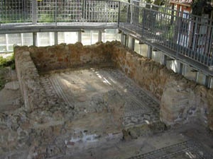
Remnants of the Roman presence in the region can be seen in the archaeological excavations in Skal of a 3rd century AD Roman villa, whose mosaic floors are of particular interest and beauty.
Buring the Byzantine period, the region developed culturally, as can be seen in the records kept by the Latin bishopric or diocese, and from the evidence found in Byzantine monasteries and churches.
The monastery of the Virgin Mary in Atrosis is one of the oldest Byzantine monasteries on the island, and has an impressive fortified 15th-century “tower” of great historical importance.
Records have been kept of property ownership by noblemen in Elios and Skala during the years of Frankish rule (12th – 15th centuries), while the period of Venetian rule (16th – 18th centuries) is mainly characterised by a surge in the number of arrivals of settlers and soldiers (“stradioti”) from other areas in Greece.
These colonists are the ancestors of many of the families living in the region today.
The constant change in rulers following the end of the Venetian domination of the island (1797) and the many political changes during the two French occupations of the island, the Russo-Turkish alliance, the Eptanisos State and the British Rule (the “Ionian State” was under British “protection” from 1817 until the Union of the Ionian islands with Greece in 1864), also had profound effects on the lives of the island’s residents, who put up a brave resistance during these periods.
Resistance groups had been active in the region since the start of the Venetian rule, but continued during later occupations, most notably in Skala and the surroundings areas in 1849 against the British Protectorate; a great deal of blood was shed during these upsrings, which led to the eventual Union of the islands with the mainland of Greece.
SIGHTS
 BEACHES
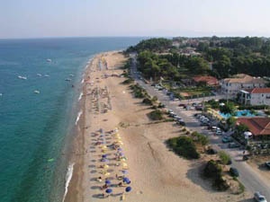
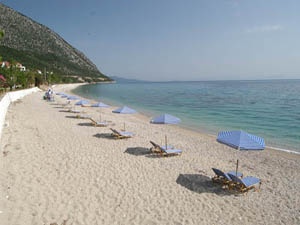
In the southern part of the Municipality we come across one of the most beautiful beaches of Kefalonia, the beach of Skala. Three kilometres of golden sand and multi-coloured pebbles,fringed with fragrant pine trees and the amazing vegetation which is characteristic of the whole region.
Skala is rightly called the most beautiful tourist resort of the island.
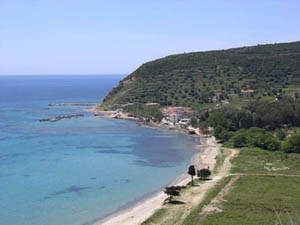
Following the coastline in a south-westerly direction we first come to Potamakia beach and then Kaminia beach; an enormous expanse of fine golden sand and clear shallow waters, which is chosen by the caretta-caretta turtles as a breeding ground.
The coastal road continues to the delightful sandy beach of Katelios, with its fish tavernas situated along the beach. Just beyond, you can swim in the unbelievably clear, turquoise waters of Koroni and Lefka beaches.
 Taking the coastal road to the east of Skala, we find ourselves in the region of Pronni, with its amazing beaches.
The coast road linking Skala with Poros – the picturesque village in the south-east of the island with the main port of the area- passes above the sea offering panoramic views of enchanting creeks and beautiful pebble beaches.
Kako Lagadi, perhaps the most attractive of these, can be reached via a small path. The road runs right next to the sea in Limenia, revealing yet another delightful cove.
Poros boasts a wonderful beach that runs from the town to the area known as Ragia.
Travelling along the coast towards Sami, we find the beaches of Makria Petra, Koutsoupia and Spilitsa, with dozens of other small coves.
This coastline is only accessible only by boat, and thus constitutes a paradise for those who want to get away from the crowded beaches and enjoy the peacefulness of the coastal landscape.
 The Mediterranean monk seal (monachus-monachus) lives and breeds in small caves along the shores here, but sadly is an endangered species.
The beaches of Skala, Katelios and Poros have all been awarded the “Blue Flag” by the European Union, for their clean waters and their facilities.
Arginia. It is the site of a collapsed wall, built before the classical era with roughly-hewn limestone, which is thought to have been originally of an imposing width and length.
It was the archaelogist, Andreas Sotiriou, who recently discovered the remains of the wall.
Palaiokastro. The remains of a stronghold or fortress above the villages of Saint George (A) and Kournelos (BA), which was surrounded by a second wall of the same height on the hill of “Dakori”.
The fortress had clearly been added to over the years since the classical period, when the city of Pronni was at its peak.
Large rocks and ruined walls are visible in various areas of the main fortress.
In the central area there are remains of water tanks, probably dating from medieval times, and stone structures which could have been altars at one time. This was the capital of the city-state of Pronni.
The Rienann Wall. The wall is located in Lithari to the south of the fort on Dakori hill. There is a ruin of a square tower, which is easily accessible from the road which goes from the spring in Pastra to Lithari, where there is also a sand quarry.
Pirovouni Castle. According to some recently-disputed records, this resodential fortress was the capital of the city of Pronni. The remains of the wall and the main gate of the castle are of particular interest.
The site was well-fortified and it constituted a barrier to those who wanted to invade the region from Poros beach. It’s connections with ancient history are confirmed in the name given to the southern entrance that is still known today as “Dipolia”.
The fortified tower of the monastery of Atros dates from medieval times, before the Venetian occupation of the island, and was built as a defence against raids on the monastery. It is in fairly good condition, despite having been attacked over the years, and plans for its restoration are in the pipeline.
MONASTERIES
The Monastery of the Virgin Mary, Atros. It is the only working monastery and its beginning in the region dating from the Byzantine period. The Kefalonian land registry of monasteries holds official records and a great deal of information about the monastery in a document known as the “Records of 1264″. Professor G. Pentogalos has recently published a book about the monastery, which describes its long history as a centre of worship for the area.
The Monastery of the Virgin Mary, Pigis. It was a prominent monastery from the period of Venetian rule right up to the last century. Although it collapsed in the 1953 earthquakes, a small chapel survives, along with the fairly well-preserved ruins of the monks’ cells.
Saint Nikolas in Halikiopoulou. The monastery is located immediately below Paliokastro, to the north of the road from Saint George to Asprogerakas. It was built at the end of the 16th century and closed towards the end of the 17th century. The church itself survived up to the 1953 earthquakes, and there are the ruins of the church and the monks’ cells to explore.
Analipsi Monastery in Skala. The monastery was founded during the period of the Venetian rule, and was at various times a dependency of the monasteries of Pigi and Sissia. It was a working monastery up to the Second World War. The church itself has been rebuilt and few traces of the original buildings survive.
Saint Anargiri Monastery, Pastra. It is believed to have been situated on the road that led from Elios, Katelios to Koronoi and Arakli. A nun was said to be in residence at the monastery for many years.
ARCHAEOLOGICAL SITES
 The prehistoric Cave of Drakaina near Poros served as a dwelling-place for man as long ago as 5000 BC. As well as a shelter, the inhabitans used it as a place of worship for their deities. Artefacts from the classical era were found there that testify to this practice, and excavations are still being carried out in the cave.
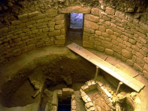
The vaulted tomb from the Mycenean period in Tzannata was used fromm 1350 to 1000 BC, according to archaelogist L. Kolonas. It is the most significant tomb of its type in the whole municipality of Elios – Pronni, and its golden artefacts discovered there are proof that it was the burial place for rich and powerful noblemen.
The Mavrata tomb was discovered by the archaeologist Marinatos and has a dome or vaulted roof. Unfrotunately, it is not accessible to visitors.
Poseidon’s Temple in Skala. The foundations of Poseidon’s Temple have been excavated and restored. The temple dates from the 6th century BC and is located in the village of Saint George. Next to the village church you can see some of the surviving temple columns.
On the nearby beach there are shards of ancient pottery and indecipherable carvings on the rocks.
Roman villa. The Rpman villa with its intricately-patterned mosaic floor, can be found in the southern part of the village of Skala.
Saint Barbara in Katelios is undergoing excavation work led by the archaelogist A. Sotiriou, who is searching for important archaeological finds from the classical period.